Willem Janszoon Blaeu (1571 Uitgeest – 1638 Amsterdam), ‘Rhenus Fluviorum Europae celeberrimus’, Karte des Rheins, 1635, Kupferstich
- Technik: Kupferstich auf Papier
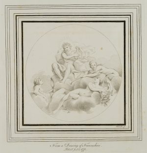
- Bezeichnung: Links oben mit dekorativem Meilenanzeiger mit Putten, die die Wappen der Gebiete halten, die vom Rhein durchflossen werden: Schweiz, Elsaß, Rheinpfalz, Mainz, Trier, Köln sowie Kleve, Geldern, Utrecht und Holland. Rechts mit allegorischen Darstellungen von Rhein, Mosel und Maas. Rechts oben eine Kartusche mit Signatur des Künstlers.
- Datierung: 1635
- Beschreibung: Dargestellt ist der gesamte Verlauf des Rheins von der Quelle in der Schweiz bis zur Mündung in die Nordsee.
- Schlagworte: Landkarten, Stadtbilder, Deutschland, Barock, 1600-1649
- Größe: 47,5 cm x 100,3 cm, Druckplatte: 41,8 cm x 95,4 cm, Darstellung: 41,0 cm x 95,2 cm
- Zustand: Guter Zustand. Noch guter Zustand. Mit deutlichen Gebrauchsspuren. Die Karte hat sich altersgemäß verfärbt und ist fleckig, stellenweise mit Flüssigkeitsflecken an den Blatträndern. Mit Rissen und Fehlstellen insbesondere an den oberen Blatträndern. Die Ecken sind bestoßen. In den Falzen leicht bis ganzseitig gerissen, mittig provisorisch restauriert.
English Version:
Willem Janszoon Blaeu (1571 Uitgeest – 1638 Amsterdam), ‘Rhenus Fluviorum Europae celeberrimus’, Map of the Rhine, 1635, Copper engraving
- Technique: Copper engraving on Paper
- Inscription: Top left with decorative mileage indicator with putti holding the coats of arms of the areas through which the Rhine flows: Switzerland, Alsace, Rhine Palatinate, Mainz, Trier, Cologne as well as Cleves, Guelders, Utrecht and Holland. On the right with allegorical representations of the Rhine, Moselle and Meuse. On the upper right a cartouche with the artist’s signature.
- Date: 1635
- Description: The entire course of the Rhine from its source in Switzerland to its mouth in the North Sea is shown.
- Keywords: before 18th century, Baroque, Maps, Germany,
- Size: 47,5 cm x 100,3 cm (18,7 x 39,5 in), Plate: 41,8 cm x 95,4 cm (16,5 x 37,6 in), Depiction: 41,0 cm x 95,2 cm (16,1 x 37,5 in)
- Condition: Good condition. Still in good condition. With clear signs of use. The map has discoloured according to its age and is stained, in places with liquid stains at the sheet margins. With tears and missing parts especially at the upper sheet margins. The corners are bumped. Slightly torn to full page in the folds, provisionally restored in the centre.